May 17, 2022
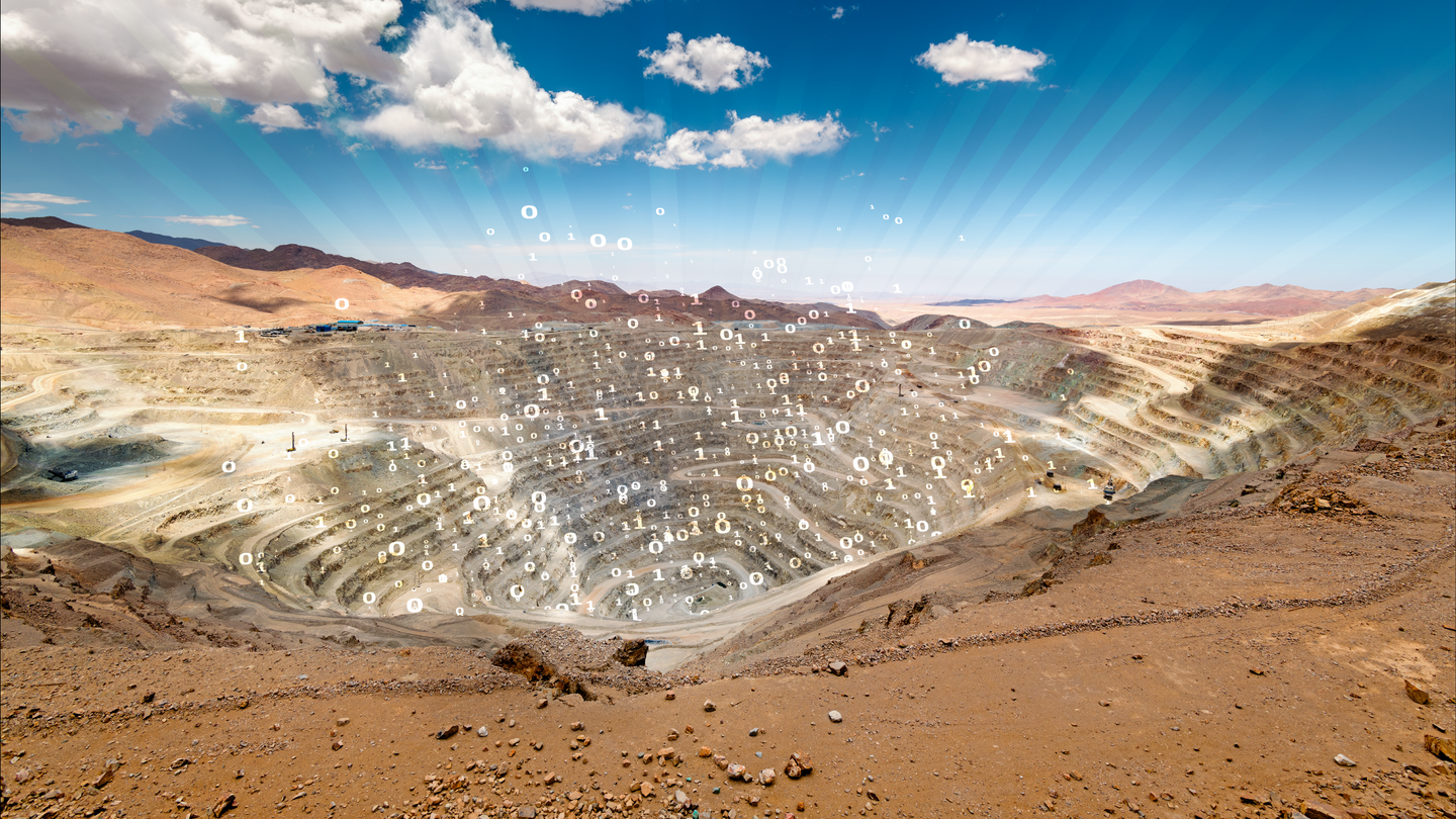
The energy transition is dependent upon the supply of critical minerals such as copper, cobalt, or lithium, to provide raw components for electric vehicles, renewable energy generation, power networks and battery storage (Figure 1). The electrification and infrastructural upgrades required by 2050, for example, to meet climate change mitigation measures will necessitate more copper to be extracted than has been mined in human history (IEA 2021).
Globally as it becomes increasingly difficult to find large tonnage and high-grade mineral deposits at or very near the surface, especially of commodities that will increasingly be needed for the energy transition, those prospecting to expand their portfolios need to look deeper and beyond known occurrences. New ways of thinking about exploration, prediction into deeper levels of the crust, and ultimately production, must be adopted. The hydrocarbon industry has been successfully exploring the subsurface for decades and making predictions into the unknown. These predictions are based on data, regional knowledge and data-driven models to build and provide robust global geological frameworks. They are the ideal testbeds to generate, scrutinize and refine geological ideas, as well as for identifying risks in subsurface and frontier exploration.
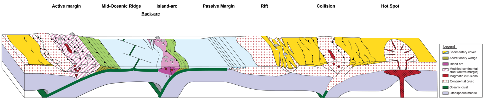
We have started taking applicable geological subsurface screening methods from the hydrocarbon industry and begun applying them within a wider mineral system approach to metal exploration. For instance, the formation of most mineral deposits, at some level, are intimately linked to a geodynamic context e.g., porphyry Cu-Au-Mo deposit associations with subduction zones and the development of an active sustained volcanic arc (Sillitoe, 2010; Groves et al., 2005). These features can be tracked and understood throughout geological time using the tools we already use in global/regional hydrocarbon exploration.
This approach echoes the routinely used petroleum system way of thinking in hydrocarbon exploration, so, for many in the oil and gas industry, this will not be an alien concept. However, it is only starting to take hold in the mineral sector. The approach aims at identifying the key elements that are required within a working economic system, the key geological time frames needed, and more importantly, the order of these events, so that one can make informed predictions about locations of resources in the subsurface.
The mineral system approach conceptualizes the occurrence of deposits based on their wider genetic models of formation, the transport and trapping of metal rich fluids, and ultimately their preservation (Wyborn et al., 1994; Hronsky and Groves, 2008). It is based on the integration of geological and physical information over time and paleo-location, and as such, plate tectonics is of prime importance in a wide range of these systems (Figure 2). Geodynamic settings have a direct connection to mineral systems and ultimately to economic deposits located within the subsurface. Therefore, understanding tectonic domains throughout time should be seen as the first step to understanding mineral formation within a wider context of mineral driving forces.
But thus far, the integration of plate tectonics, despite being accepted as an integral part of the mineral systems approach, has not been fully integrated into the exploration workflows. Recent developments (Wrobel-Daveau and Nicoll, 2022) are establishing new ways of addressing this challenge and aim to provide ground-breaking methods for bringing plate tectonic modeling right into the core of the mineral systems approach workflow, while also allowing one to make (and test) predictions in the subsurface as well as frontier regions.
Recent advances in plate tectonic modeling quality and detail enable tools for prediction and screening of geodynamic context-dependent natural resources with a higher level of precision and confidence than ever before. The Neftex® plate tectonic model is unique in its approach (Wrobel-Daveau et al., 2020). In addition to the motions of continental blocks, plate boundaries are calculated between increments of time following the “dynamic plate boundaries” or “dual control method” (e.g., Stampfli and Borel, 2002; Vérard, 2018), while providing a framework to build “true” global plate tectonic models (Hochard, 2008), respecting rigid plate principles (McKenzie and Parker, 1967; Le Pichon, 1968). As such, a continuous and globally consistent representation of plate boundaries can then also be used in exploration geoprocessing workflows to predict the occurrence of natural resources.
In order to apply this wider concept more efficiently within industry and for targeted mineral exploration specifically (here, porphyry Copper deposits), a new approach to the global screening of volcanic arcs, and their cumulative durations, as a predictive method for potential magmatic/hydrothermal deposit occurrences was proposed (Wrobel-Daveau and Nicoll, 2022). It utilizes geospatial and temporal analytics running on a combination of large global datasets and a global plate model (0 - 600 million years) that contains detailed plate tectonic boundaries.
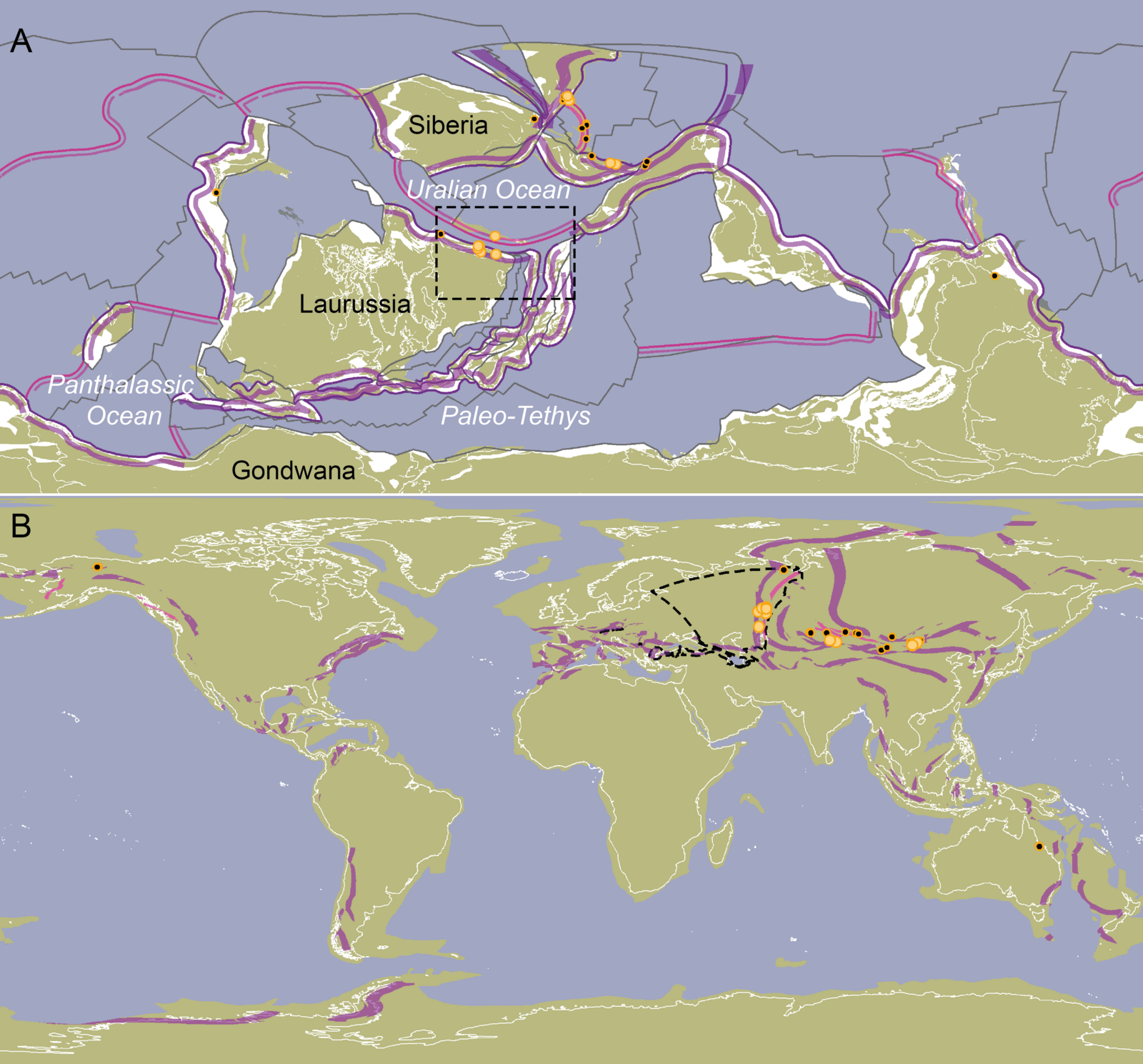
The method involves 1) calculating the present-day distance between arc volcanoes and their respective subduction trench in both continental and intra-oceanic settings in order to establish robust global statistics; 2) applying these values on subduction plate boundaries (i.e., continental active margins and intra-oceanic subductions) to geo-process the average distance to trench and width of magmatic arcs in both present-day and in paleogeography, Figure 3 (for all the 52 reference reconstructions in the Neftex plate tectonic model); 3) un-reconstructing back to present-day geography and combining these modelled paleo-magmatic arc locations with their total durations to calculate the total cumulative magmatic arc duration at any location.
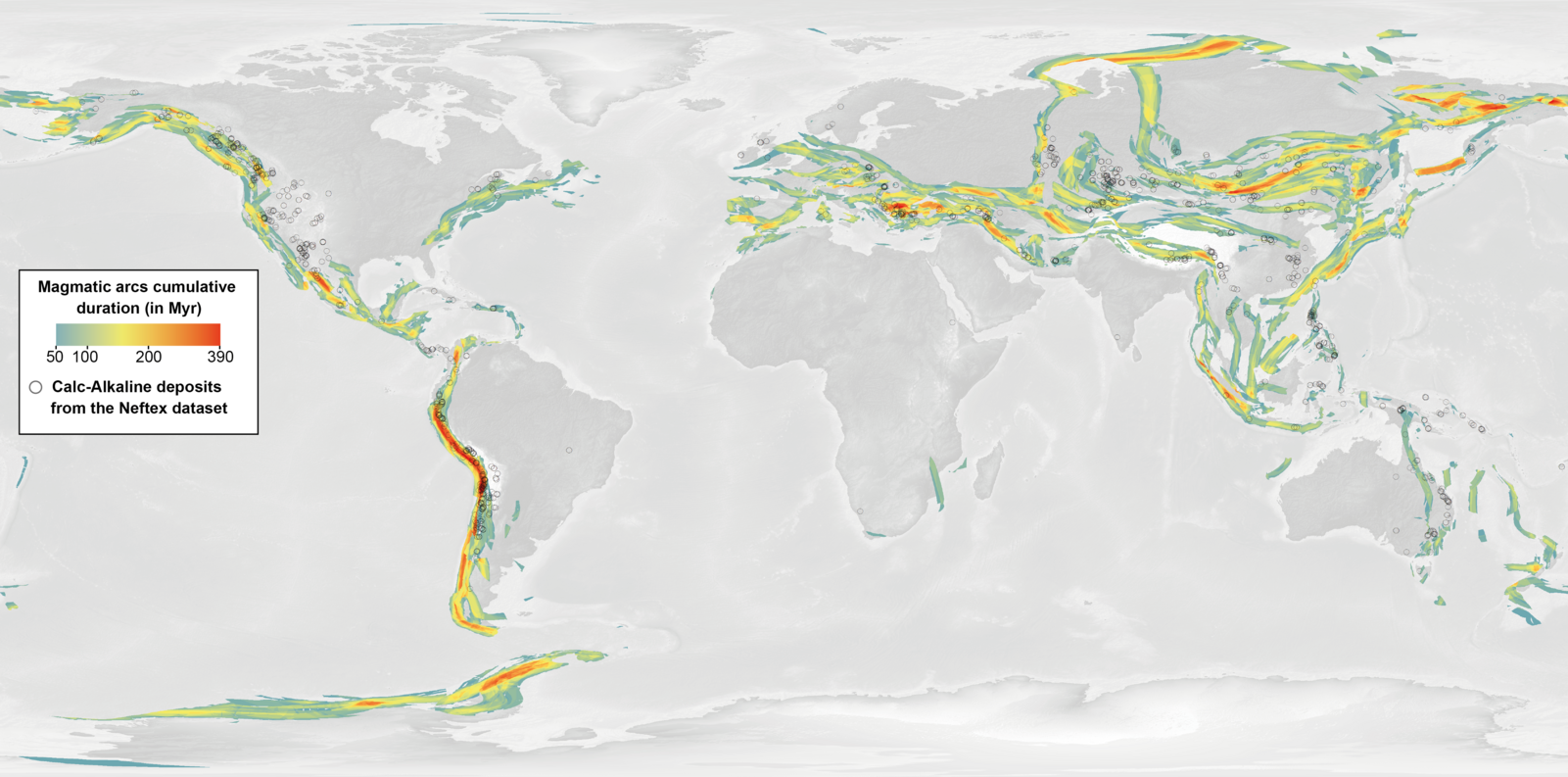
This results in a spatio-temporal model of magmatic arc total cumulative durations at the global scale, back to 600 Ma, that can serve as a proxy to predict mineral system likelihood (here, porphyry deposits, Figure 4). The modeling output has been tested against a porphyry occurrence dataset to validate the approach as a predictive proxy for arc-related deposits. The alignment of modeling results with data control is high (75% correlation averaged on geological Periods throughout the Phanerozoic, see Wrobel-Daveau and Nicoll, 2022).
This methodology can then be used to examine the locations of known hydrothermal subduction zone related mineral deposits and then refined with additional proprietary data to make regional predictions into the unknown away from data control, greenfield and deep undercover.
Neftex® has been gathering data from the public domain and integrating it within a spatio-temporal framework, supported by its proprietary sequence stratigraphic and plate tectonic models, for over 20 years (Head and Simmons, 2021; Simmons, 2021). This has been used to derive additional interpretative products which have successfully helped predict and explore for hydrocarbons. While building up this data and interpretive content, Neftex has effectively created a fully integrated model of the Earth’s evolution through geological time. This can be used to understand the geological evolution of regions and test additional concepts beyond hydrocarbons, with themes important for the energy transition such as: Carbon Capture, Geothermal, Hydrogen, and Minerals (Figure 5).
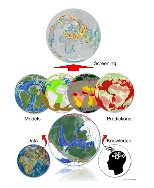
Content from Neftex, targeted for the mineral exploration sector, can identify relevant geological key components for understanding mineral driving forces and help bring a mineral systems approach to exploration. Our newest offering, Neftex® Prospect a DecisionSpace® 365 cloud solution, offers data, robust tools, comprehensive tectonic insights and integrated workflows to help confidently scout for mineral systems deep in the subsurface and across new frontiers. We can provide cross-industry collaboration, relevant content, and applications at your fingertips to enhance your mineral screening workflows. Empower your team to discover and develop the most profitable and sustainable mineral projects by leveraging robust global geological frameworks built from data, regional knowledge, and data-driven models.
The future evolution of this, as we work with our clients, is to further bring these components together to allow for better understanding and ultimately the efficient screening of individual geological elements important within the mineral system while also understanding their successive timing at any location on Earth, (like we currently do for hydrocarbons - see Wiltshire and Treloar, 2019). This allows one to investigate and test many different scenarios rapidly, as well as to rule out areas where geological conditions may not be favorable (saving time and money on potentially unsuccessful exploration). This can also be significant for portfolio management: from grassroots exploration, competitor intelligence, the geological evaluation of projects, and to help rank potential acquisitions.
To know more, watch the webinar!
References