Azimuthal gamma ray images uncover stratigraphic features in a seemingly featureless unconventional reservoir
Download PDFUnconventionals

Wellbore placement in a formation with little gamma ray variation

Middle Bakken Shale, North Dakota

An operator in North Dakota’s Middle Bakken shale formation sought a cost-effective solution that would enable effective drilling and geosteering in a formation with little gamma ray variation. The operator used the Radian® azimuthal gamma ray and inclination service to better understand the stratigraphy of the formation and the wellbore position within the reservoir.
Unconventional resources are often costly to produce because of the need for hydraulic fracturing. In order for these shale plays to be considered economical, operators seek cost-effective solutions, drilling and geosteering wells with average gamma ray measurements from logging-while-drilling (LWD) solutions. While the Three Forks formation has sufficient gamma ray character to effectively geosteer, the wellbore placement in the Middle Bakken formation can be more challenging because of the limited gamma ray variation, making it difficult to interpret structural changes along the wellbore.
A new high-quality azimuthal gamma ray service helps to better understand the stratigraphic location within the formation and the instantaneous drilling direction.
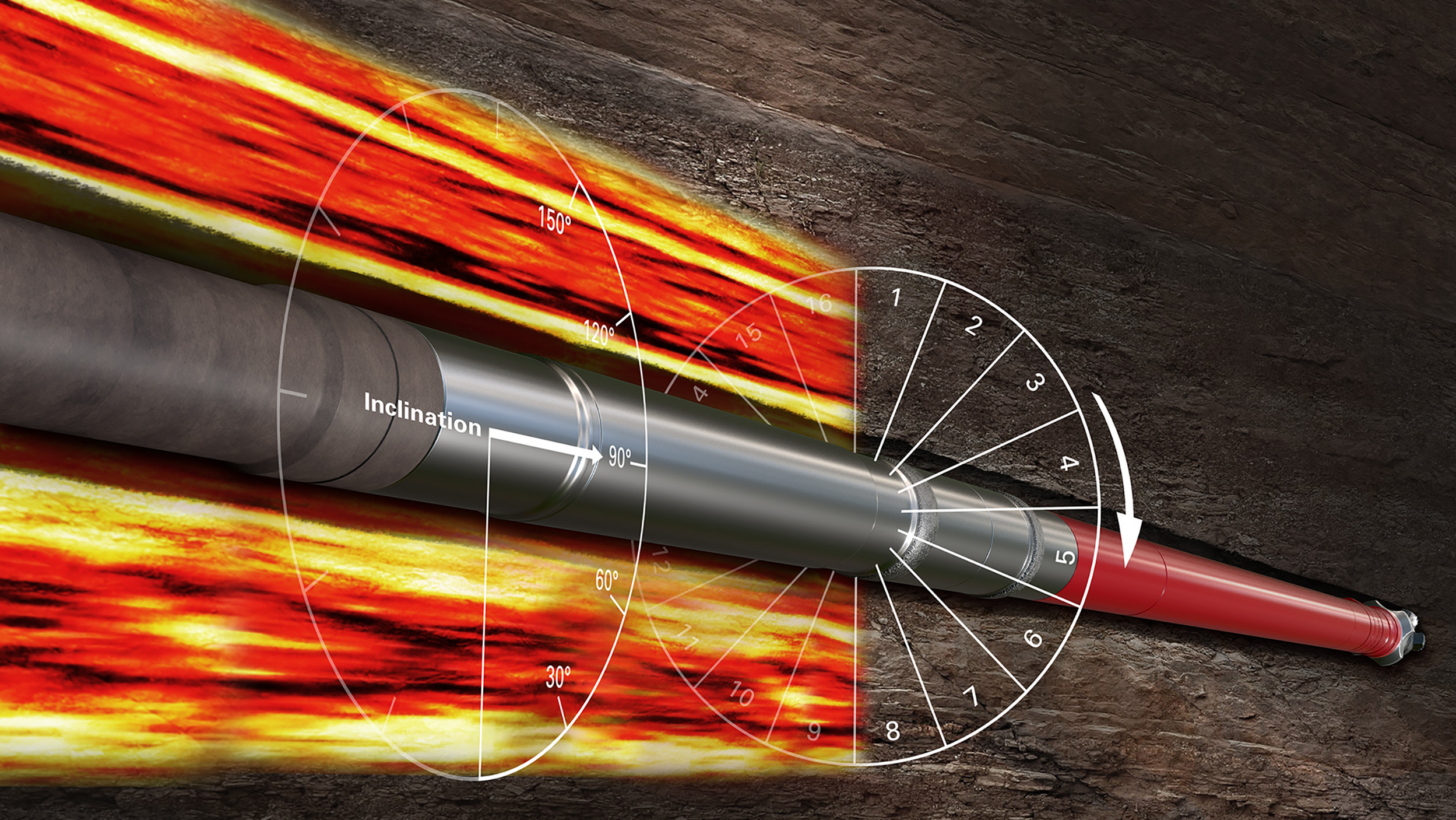
At the recommendation of Sperry Drilling, the operator drilled two wells using the Radian azimuthal gamma and inclination service. The Radian service features four scintillation detectors spaced 90° apart that allowed for gamma-ray imaging while rotating or sliding, along with an inclinometer that provided continuous inclination measurements for real-time monitoring of the well trajectory. Even with low gamma-ray variations in the formation, the target zone can be precisely identified based on the superior gamma-ray images provided by the Radian service. In addition, the Radian tool allowed for an enhanced survey based on the continuous inclination data for a more accurate structural map. A stratigraphic correlation between average (non-azimuthal) gamma-ray measurements and the enhanced survey was performed on one of the two wells in real time. Real-time interpretation of Radian data made it possible to detect the stratigraphic movement of the wellbore, where bulk gamma-ray measurement was featureless.

Continuous inclination measurements and real-time high-quality gamma ray images enabling better geosteering decisions and accurate well placement.
StrataXaminer™ provides more accurate well data to better evaluate production potential and increase return on investment.
High-resolution ultrasonic imaging service shows fractures and geological features in all mud types.