EarthStar™ ultra-deep resistivity service combined with unique, industry-leading 3D inversion sheds new light on mature reservoir
Download PDFMature Fields

Efficient exploitation of remaining reservoir reserves
Norwegian Continental Shelf

An operator has been drilling multiple wells in a mature carbonate field on the Norwegian continental shelf, with a long history of production and water injection. The field exhibited significant dislocations of the reservoir formations due to fractures, slumping structures, and faults. Variable permeability further complicated the distribution of fluids. The complex resistivity distribution, associated with lateral changes in the fluids and lithology, made well-placement decisions very challenging. The complex structure also made predictions of future production very difficult.
While the operator had previously used ultra-deep resistivity and quad-combo logging while-drilling (LWD) tools for well placement and geomapping of surrounding formations, the results were limited to 2D cross-sectional plots along the wellbore. It would take 3D inversion visualization capabilities to gain a true picture of the reservoir for efficient exploitation of remaining reserves. Halliburton Sperry Drilling recommended the EarthStar™ ultra-deep resistivity service, which can provide real-time information about the resistivity distribution within the reservoir on a scale not possible with any other type of measurement. This service is proven to map reservoir and fluid boundaries up to 225 feet (68 meters) from the wellbore — over twice the depth of investigation of the previous industry standard. It is also combined with 3D inversion for enhanced reservoir understanding.
Halliburton utilized ultra-deep LWD resistivity data, delivered by the EarthStar service, to conduct an in-depth, post-well study on a trial well, applying 3D inversion techniques to the EarthStar measurements. The most revealing discovery was a tilted oil-water contact near the heel of the well, which meant that the traditional assumption, that the contact would be horizontal, did not apply. More significantly, the 3D inversion demonstrated that this tilted contact crossed the well path laterally at an oblique angle, indicating that an azimuthal adjustment of the well path would have provided significantly greater hydrocarbon exposure. The results showed that faults separating zones of water invasion also crossed the well at an oblique angle. Anticipation of such faults would have reduced drilling risks and allowed for better-informed well-placement decisions. Finally, the operator was able to see that some parts of the well passed close to oil-water contacts associated with waterflood fronts, which were visible to one side of the wellbore. This was critical information, essential for determining how to best complete the well and predict future production.
This innovative technique resulted in an excellent representation of the subsurface geology and fluids, by calculating and displaying the distribution of resistivity around the wellbore. It clearly demonstrates that 3D inversion data helped the operator enhance reservoir understanding by delivering valuable insight into the characteristics of the reservoir compared to 2D inversion, maximizing asset value.
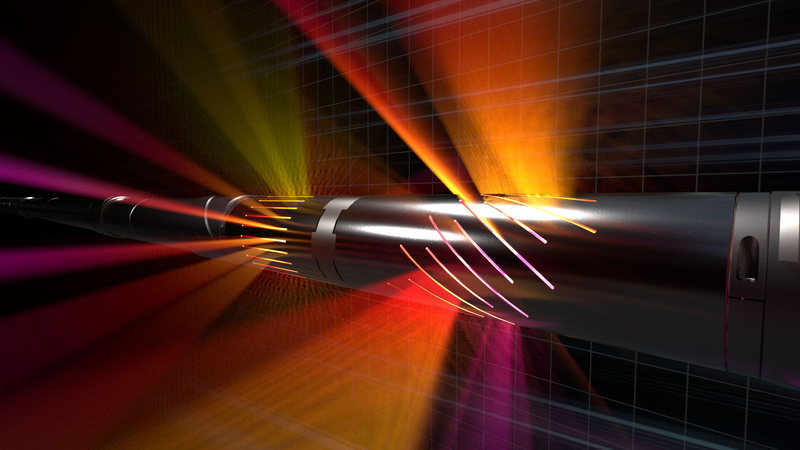
Ultra-deep resistivity service mapping reservoir and fluid boundaries up to 225 feet from the wellbore.
Gather real-time, high-quality data while drilling for improved subsurface insight, increased ROP, and enhanced wellbore stability